Difference between revisions of "MapRegions"
m (Added headers) |
(Adjust the explanation of the colors.) |
||
| (3 intermediate revisions by 3 users not shown) | |||
| Line 1: | Line 1: | ||
| − | == | + | == Description == |
| − | [https://project-gc.com/Tools/MapRegions Map Regions] is a tool where users with a [[paid membership]] can get an overview of what [[region]]s in a country they have logged a geocache in and which they have not logged a geocache in. The map can also be used to find suitable caches for logging that region. | + | [[File:MapRegions.png|200px|thumb|right|Map Regions showing Sweden.]] [https://project-gc.com/Tools/MapRegions Map Regions] is a tool where users with a [[paid membership]] can get an overview of what [[region]]s in a country they have logged a geocache in and which they have not logged a geocache in. The map can also be used to find suitable caches for logging that region. |
The search is done at country level and the result shows as a map with the standard [[map feature]]s, under the map are information about how many regions the user have logged in the country and how many regions there are in the country. All the regions and the number of caches the user have logged in each region are listed in alphabetical order under the map. | The search is done at country level and the result shows as a map with the standard [[map feature]]s, under the map are information about how many regions the user have logged in the country and how many regions there are in the country. All the regions and the number of caches the user have logged in each region are listed in alphabetical order under the map. | ||
| Line 18: | Line 18: | ||
== Usage == | == Usage == | ||
| − | Clicking on a region will give a small box with the number of finds and the name of the region | + | Clicking on a region will give a small box with the number of finds and the name of the region. Clicking the text in the box will show the geocaches available in the region. |
== Colors == | == Colors == | ||
| − | The polygons of | + | [[File:MapRegionsColorBlind.png|100px|thumb|left|Color Blind-mode]]The region polygons are displayed in one of three colors: red polygons indicate regions where the user has not found a cache; green polygons indicate where the user has found either a cache, or enough caches, if the 'Loop' filter is applied. The third color is a mix of red and green; this indicates that the user has found enough caches but only if caches with coordinate issues (such as [[Antipode cache]]s) are included. In [[Color blind mode]] blue is used instead of red; the red-green mixed color remains the same. |
[[Category:Tools]] | [[Category:Tools]] | ||
Latest revision as of 21:33, 26 October 2024
Contents
Description
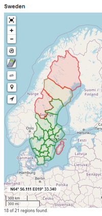
Map Regions is a tool where users with a paid membership can get an overview of what regions in a country they have logged a geocache in and which they have not logged a geocache in. The map can also be used to find suitable caches for logging that region.
The search is done at country level and the result shows as a map with the standard map features, under the map are information about how many regions the user have logged in the country and how many regions there are in the country. All the regions and the number of caches the user have logged in each region are listed in alphabetical order under the map.
Filters
The filters available for the tool are:
- Profile name
- Country
- Cache type / size
- Difficulty / Terrain
- Logdate
- Show Disabled/Archived
- Loop
- Custom filters
It should be noted that these filters generally only affect the geocaches shown on the map, not if the region would be considered logged or not. The Logdate-filter would be the exception since it can be used to show how many regions the user logged during a specific year or other time frame.
Usage
Clicking on a region will give a small box with the number of finds and the name of the region. Clicking the text in the box will show the geocaches available in the region.
Colors
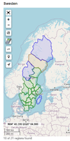
The region polygons are displayed in one of three colors: red polygons indicate regions where the user has not found a cache; green polygons indicate where the user has found either a cache, or enough caches, if the 'Loop' filter is applied. The third color is a mix of red and green; this indicates that the user has found enough caches but only if caches with coordinate issues (such as Antipode caches) are included. In Color blind mode blue is used instead of red; the red-green mixed color remains the same.

